| The History and Significance of Centreville, Virginia | ||||||||||||||||||||||
|
by Debbie Robison October 22, 2006 | ||||||||||||||||||||||
| SIGNIFICANCE OF HISTORIC CENTREVILLE |
| The historic Centreville area is significant within the chronologically-based historic contexts of:
In addition, throughout its history, the area reflected the broad patterns of cyclical economic prosperity and decline. COLONIAL AND EARLY-NATIONAL PERIOD DEVELOPMENT AND EXPANSION |
| After the available land was settled in the Northern Neck of
Virginia, planters began acquiring land in the northern portion of
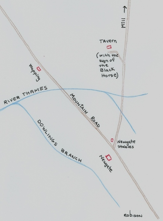
By 1768, at the intersection of a road from Willoughby
Newtons ca. 1746 water mill, a tavern known as Newgate
was constructed to provide lodging and meals to travelers along the A store was constructed on the In support of the tavern and
store, a community of craftsmen developed. In 1766, Willoughby Newton leased portions of his land grant to tenant farmers. Two of the tenant farms were located in the expanded historic district study area: William Grove leased 100 acres in 1746, and William Remey leased 150 acres the following year.[5]
Courtesy Library of Congress, Geography and Map Division DEVELOPMENT OF A MERCANTILE, MANUFACTURING, AND TRAVELERS' TOWN |
| The Town of In 1790, three years after The petitioners suggested that the A second petition was submitted to the Legislature in October 1792, the year the General Assembly enacted legislation founding the town.[10]
Like many Colonial and Early-National Period Virginia towns, Centreville was laid out in a gridiron plan, an ancient land-planning system generally thought to have been developed by a Greek planner, Hippodamus of Miletus.[11] Courtesy Library of Congress, Geography and Map Division The town was divided into
128, one-half acre lots. The existing turnpike road, realigned to fit the grid,
became the 60 wide Town development established a pattern of mixed residential and commercial use. Residential frame houses, taverns, stores, and manufacturing concerns were constructed on the town lots, typically close to and facing a street. Tanyards were sunk along the River Thames. Newspaper advertisements and deed records corroborate this development pattern. For example:
Many of the structures were frame construction over a foundation of irregularly coursed local, red-fieldstone rubble. The gable-end roofs were pitched, often penetrated with dormers. The siding was often clapboard or board & batten. Entryways were often covered with porches or porticos. Travel continued to have an impact on the prosperity of the
town. Though the town citizens petitioned against relocating the turnpike road
north of the town, thus bypassing their establishments, the Little River Turnpike
was constructed connecting CIVIL WAR OCCUPATION |
| Because of Centrevilles
strategic location on high ground between Manassas Junction and Washington, and
its relation to the turnpike and railroad systems, both Union Occupation: July 18,
1861 ca. July 26, 1861 |
| On July 18, 1861, Brigadier
General Irwin McDowell arrived in Confederate Winter
Encampment: October 16, 1861 March 8/9, 1862 |
|
Courtesy Library of Congress, Prints & Photographs Division By October 1861, General Johnson was planning for the construction of a winter encampment at Centreville. Framework from dilapidated and deserted buildings was taken to camp for the construction of substantial houses. Sufficient supplies of lumber could not be salvaged to construct enough housing for 40,000 soldiers, thus trees were felled for the construction of log cabins, leaving the area devoid of trees. [27] By the end of December 1861, Confederate troops had built over fifteen hundred log cabins housing from eight to twenty men each. Union Survey: March 10, 1862
ca. March 13, 1862 |
|
Upon entering the Confederate fortifications, the troops confirmed that the embrasures contained large logs, dubbed Quaker guns instead of bona fide artillery pieces. Courtesy Library of Congress, Prints & Photographs Division Union Occupation: By June 20,
1863 ca. October 14, 1863 |
| Union Brigadier-General Rufus
King held Centreville with Infantry and Cavalry who were often sent out in
search of guerrillas, specifically White and Mosby. By October 4th,
King had moved on to Fairfax Courthouse, having until then kept a long line of
pickets in front of Centreville. On October 13, 1863, Major-General Meade
ordered the army massed at Centreville. It
was hoped that the Union army was sufficiently far ahead of the Confederates to
enable the seizure of the Robert Sneden,
a Union cartographer, created a map in September 1863 titled, New Defences
Erected at Centreville POST CIVIL WAR RECOVERY |
| Centrevilles modest recovery
from the war was slow. The underlying advantage upon which Centreville achieved
early success was the central location of the town at the intersection of an
extensive road network. The heavy traffic of war destroyed the roads. In 1916,
travelers from Prior to the war, a large portion of the lots and land surrounding the town was purchased during a period of economic recovery and business expansion by a local land speculator, Alexander Spotswood Grigsby. Due to the impact of war on the land and buildings, values depreciated significantly, forcing Grigsby into financial ruin. It took over 23 years, from 1869 to 1892, for the Commissioners for the Court to sell off Grigsbys Centreville area real estate.[30] As new owners came to Centreville, businesses were established and homes built. In 1866, S C Spindle, a harness-maker, purchased the house known today as the Harrison House.[31] In 1875, Thomas D. Harrison, a blacksmith, purchased the house and lot and began making improvements, as evidenced by the nails he purchased at the John DeBell store.[32] William H. Utterback purchased one-acre of land from the Grigsby Commissioners in 1869, towards the eastern end of town, where he constructed a store, operated a post office, and provided rooms for travelers.[33] Two churches destroyed during
the war were replaced with new structures. The Robert V. Utterback may have constructed a home, now known as the Hardee Chambliss Law Office, c. 1897.[35] In 1870, a correspondent for the Alexandria Gazette found Centreville improving, yet bearing marks painfully visible We found the village contained beside the dwellings, three stores, two black smith shops, two wheel-wright shops, shoemaker shop, harness shop, etc.[36] The Washington Star Rambler
described MOTOR-CAR TRAVEL AND TOURISM PROSPERITY |
| The proliferation of automobiles brought motorists touring the countryside. Motoring to various destinations became a worthy mention in the societal columns of local newspapers. Road improvements brought a measure of prosperity to Centreville. In 1915, the road through
Centreville remained in poor condition. The Washington Post suggested a driving
tour from Interest began developing in
1916 to create trunk line highways in As a scenic route it is hard to improve
upon. Every foot of the way is of interest to the seeker in historic
lore
Centreville was one of the great stopping places for stage coach lines in
the olden days, and most all of the houses have historic memories connected
with them
When this road is completed it will make one of the most delightful
drives out of Washington for the automobilists. Places of interest, beautiful
scenery and a smooth road are all that the average tourist asks for.[39] The road improvements enabled
tourists to travel, stopping along the route at historic points of interest,
such as Centreville. When the A groundswell of support arose in the early 1920s to
create a transcontinental road to make an automobile trip from coast to coast a
possibility at all times. The Lee Highway Association (formed in 1920),
assisted by the American Automobile Association, developed a plan to link Portions of the Warrenton-Fairfax turnpike were included in
the Businesses opened along Just east of Paynes Market was Bens Lunchroom, owned and
operated by Ben Cross, along with tourist cabins. The tourist cabins were later
owned by Carroll Carter, who acquired property on Carters property had a stone filling station constructed of
stone taken from the nearby dilapidated Four Chimneys house, which was used as
a headquarters during the Civil War. Two local stone Masons, Pinkey McWhorter and Will Crouch used a model A pickup truck to haul the stones to Centreville was able to capitalize on its history, becoming
a tourist attraction for motorists traveling in their touring cars. Immediately
following the completion of Improved roads facilitated construction of residential housing for commuters. Roger Spindle, a government post office department employee, had a Sears catalog kit house constructed in Centreville in 1934. A garage and driveway was built west of the house as an area for Spindle to park his motor car.[45] Early first generation subdivisions in the Centreville
area included the Katherine T. Moore subdivision (May 1938), which was by and
large demolished to make way for the Little Rocky Run subdivision, and Ratcliffes subdivision (July 1938), which retains several
original houses.[46] Both of
these subdivisions, constructed on N.B. |
| A common thread that runs through Centrevilles various historical contexts is Centrevilles association with road networks. · A colonial tavern and store were constructed at the intersection to two main transportation routes. ·
The town of · Civil War strategists designed defensive fortifications at Centreville to protect against attack via roadways. · Centrevilles post-war recovery was facilitated by road improvements. ·
The transcontinental [1] Northern
Neck Grant C:38 to Robert Carter, Jr. in 1729 mentions
Walter Griffins [2] Northern
Neck Grant E:172 to Willoughby Newton for 1,719 acres
on [3] Virginia Gazette, Publisher: Rind Page: 2, Column: 3, 1771-01-17 [4] Loudoun [5] [6] Eugenia B. Smith, Centreville, Virginia Its History and Architecture, 1973, Fairfax County Office of Comprehensive Planning (now Department of Planning and Zoning) in cooperation of the Fairfax County History Commission, pp. 20,21. [7] John Stuart Alexander, and Others, Legislative Petitions, Fairfax County, November 20, 1790, Reel 49, Box 69, Folder 36, Library of Virginia. [8] Loudoun [9] John Stuart Alexander, and Others, Legislative Petitions, Fairfax County, November 20, 1790, Reel 49, Box 69, Folder 36, Library of Virginia. [10] John Stuart Alexander and Others, Legislative Petitions, Loudoun County, October 3, 1792, Reel 111, Box 142, Folder 39, Library of Virginia. [11] Philip Pregill and Nancy Volkman, Landscapes in History, Design and Planning in the Eastern and Western Traditions, Second Edition, 1999, John Wiley & Sons, Inc., New York, pp. 97-98. [12] FX DB G(7):316 [13] FX DB V2(48):72 [14] FX DB E3(57):105 [15] FX DB O2(41):40 [16] To
Rent, [17] FX DB
X3(76):183, [18] Eugenia B. Smith, Centreville, Virginia, Its History and Architecture, Fairfax County Board of Supervisors, Fairfax, VA, June 1973, p.40. [19] Ibid., p. 64. [20] FXDB
G2:366, [21] Travellers Rest, Palladium of [22]
Legislative Petitions, 111:142:52, [23]
Legislative Petitions, 49:70:23, 29, Library of [24] Official Records, Series I, Vol 2, 04 Aug 1861, p. 317. [25] Smith, p.53. [26] OR Series 1, Vol. 5, 00 March 1862, p. 54. [27] Smith, p. 57. [28]
Official Records, S. Williams, [29] Will Build New Road, The [30] [31] FX DB G4:253, August 21, 1866 [32] FX DB V4:82, December 14, 1875; DeBell Store ledgers in possession of Mildred DeBell. [33] FX DB K4(89):47, May 6, 1869 [34] [35] Land Tax Records, 1897, Improvements Added. [36] [37]
Rambler, The [38] Route
to Bull Run, The [39] [40] [41] [42] Herndon Observer, January 9, 1925, p. 4; Herndon Observer, August 20, 1925, p.1. [43] FX DB R9(226):489, March 15, 1926; FX DB W10(257):378, October 15, 1930 [44] Herndon Observer, August 20, 1925, p. 1; Herndon Observer, December 3, 1925, p. 1; Herndon Observer, January 18, 1929, p. 1. [45] FX DB M11(273):4, March 29, 1934. [46] FX DB A13(313):487, May 5, 1938; FX DB B13(314):289, July 8, 1938. |

 By the 1720s, a road was established from the
 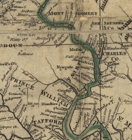 Newgate
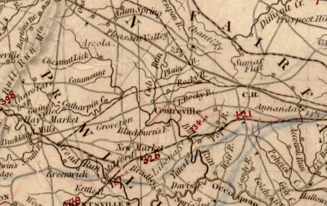 The petitioners saw the advantages of being centrally located along many
travel routes. The Herman
The petitioners saw the advantages of being centrally located along many
travel routes. The Herman 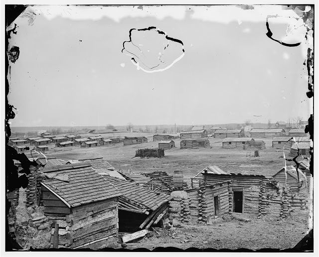 Late in the evening of
October 16, 1861, General Joseph Eggleston Johnstons army arrived in
Centreville and soon began construction of forts, breastworks,
Late in the evening of
October 16, 1861, General Joseph Eggleston Johnstons army arrived in
Centreville and soon began construction of forts, breastworks, 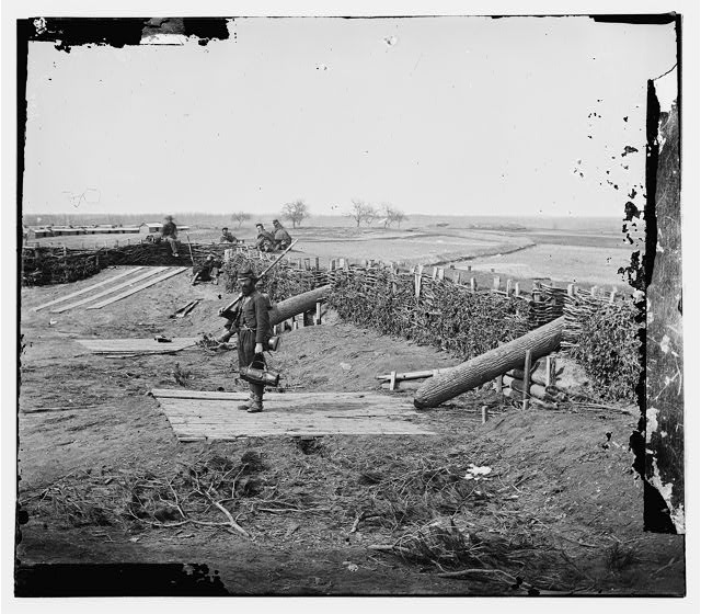 On March 10, 1862, Union
troops of General Philip Kearnys Third New Jersey Brigade and
On March 10, 1862, Union
troops of General Philip Kearnys Third New Jersey Brigade and