| Formation of the Town of Leesburg, Virginia in 1758 |
|
by Debbie Robison June 2, 2007 |
| COLONIAL SETTLEMENT |
|
Recorded settlement of the land near
the future site of Leesburg began in earnest in 1728 when several men obtained
land grants from The Right Honorable Thomas Lord Fairfax, proprietor of the
Northern Neck.[1]
The Proprietary, originally granted in 1649 by Charles II to seven of his
fathers’ loyal supporters, consisted of all of the land north of the High-acreage land grants for
nearby tracts were issued to wealthy, well-connected gentlemen shortly
thereafter. These larger tracts were likely initially planted with tobacco and farmed
by slave labor, though were, to a degree, subdivided into tenant farms in the mid-to-late
eighteenth century.[2] Frances
Awbrey, who obtained many large land grants in the
Northern Neck Proprietary, was issued a grant in 1730 for 4,054 acres on land
where the town of The following graphic depicts the locations of land grants in the area surrounding the future site of Leesburg. Only portions of the color-coded grants are shown. 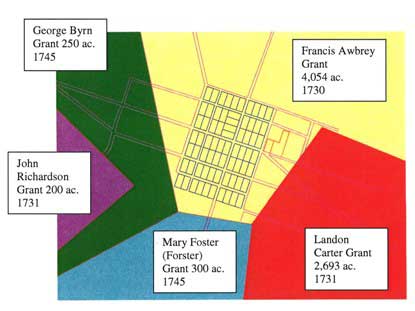
Drawn by Debbie Robison Neither the 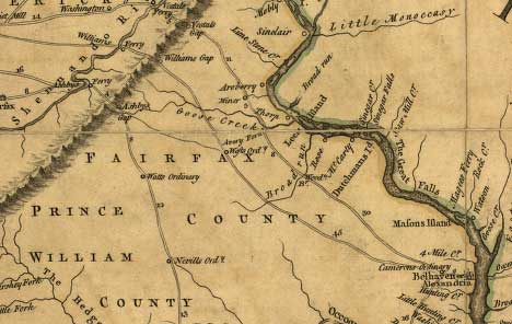
Image Courtesy Library of Congress, Geography and Map Division |
| FRENCH AND INDIAN WAR |
|
As the French increased their
efforts in the 
Image Courtesy Library of Congress, Geography and Map Division Following Fear of attack continued until
the British gained control of Nicholas Minor, living during the
conflict near present day Leesburg, became a captain in the |
| FORMATION OF THE TOWN OF LEESBURG |
|
In 1741, John Awbrey,
son of Francis Awbrey, was devised about 326 acres of
land in his father’s will. John Awbrey had already
been living on the land at the time. Three years later, at John Awbrey’s death, the land was sold by Mary Awbrey, his widow, to pay his debts.[8]
John Carlyle, an Just prior to the formation of the town of Leesburg(h), Carlyle sold the land to Nicholas Minor, Jr.[11] The town of Leesburg, originally known as George Town, was laid out in a gridiron plan of one-half acre lots about the time that Loudoun County was formed in 1757. 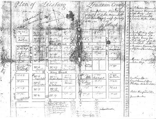
Courtesy the Thomas Balch Library, Leesburg, VA In November 1757, representing
the Inhabitants of George Town,
Nicholas Minor petitioned the The first lot was sold in
February 1758. In addition to the lots within the town, Minor sold
irregularly-shaped lots surrounding the town south of The land surrounding the town
north of |
| ENDNOTES |
|
[1] Northern Neck Grant Book B, p. 151 (NN B:151), Jacob Binks, 145 acres, 17 October 1728; NN B:157, Isaac Lasswell, 198 acres, 21 October 1728; NN B:159, Midleton Shaw, 188 acres, 22 October 1728; NN B:218, Jacob Lasswell, 140 acres, 15 March 1728/1729; NN B:153, William Matthews, 150 acres, 18 October 1728 [2] In 1738
Ann Mason purchased Francis Awbrey’s 4,054 acre
grant, less about 236 acres retained by John Awbrey.(Prince William Deed Book B, p. 9 (PWDB B:9). She purchased a portion
of this land, i.e. 645 acres, from Thomas Johns in 1747. ( [3] NN C:102, Francis Awbrey grant of 4,054 acres, 11 Feb 1730. [4] NN C:172, Landon Carter grant of 2,693 acres, 29 Jun 1731. [5] [6] [7] Harrison
Williams, Legends of Loudoun, Garrett
& Massie, Inc., Richmond, 1938, p.107; Quoting from Messrs. Patrick A. Deck
and Henry Heaton’s 1926 book titled Economic
and Social Survey of Loudoun County. [8] [9] [10] FX DB D1(4):417, 17 May 1757. [11] Loudoun
[12] [13] John T.
Phillips, II, The Historian’s Guide to [14] LN DB F:275, 18 Sep 1767. [15] LN DB L:114, 21 Feb 1775. |

| Home |