Infrastructure
History of the Luck Stone Quarry Site
Near Centreville, Fairfax County, Virginia
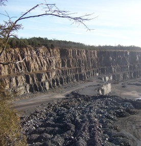
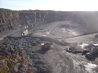
History of the Luck Stone Quarry site on Route 29 in Fairfax County, Virginia, from its geological origins nearly 200 million years ago through the establishment of a county-run quarry in 1928 and its eventual operation by the Luck family.
The history of the Luck Stone Quarry site, located on Route 29 in Fairfax County west of Centreville near Bull Run, began almost 200 million years ago. Near the end of the Triassic Period, rifts in the continent were created forming the Atlantic Ocean as well as inland basins that filled with sediment. During the Jurassic Period, sediment in the Culpeper basin, located in the northern Virginia Piedmont, was intruded by vertical diabase dikes that enabled lava to flow on the surface.1
The Culpeper basin roughly extends from the Potomac River down to Culpeper and from just east of Centreville to New Baltimore. The topography is relatively flat, except in those areas where basalt lava formed ridges. The ridge at Centreville, so important to both the Union and Confederate armies during the Civil War, was created by molten rock flows.
It is no coincidence that a quarry was established on land where basalt lava flowed so long ago. The quarry mines diabase, a dense, igneous rock. This hard rock was found to be ideal as a road bed material when Fairfax County was making a concerted effort to improve its muddy roads with gravel.
On January 2, 1928, the Fairfax County Board of Supervisors directed the County Engineer, F. Norvill Larkin, to open a quarry and to crush stone for use on the County roads.2 The Board entered into contracts with two adjacent property owners, J. R. and Daisy Wells and William and Henrietta Griffin, to lease their land for the quarry. The contracts had similar terms. The lease allowed Fairfax County
…to operate a quarry and crushing plant for the removal of stone and all by products… They have the exclusive right to quarry, crush and remove from said land all stone and by products therefrom, together with the right of erecting theron such buildings and sheds as it may deem expedient and necessary and with the full and uninterrupted right of ingress and egress to and from said land for the purpose of operating the said quarry and crushing plant…3
In return, the property owners received a royalty of three cents per cubic yard of stone sold by the quarry. To get to the diabase rock, the soil needed to be stripped from the surface. J. R. and Daisy Wells agreed that the quarry operators could spread the soil on the Wells's property from the quarry site down to the branch (a small stream.)
A quarry may have already been operating on the Wells property. The contract with Fairfax County mentioned an existing quarry.4
In May 1928, the Board of Supervisors agreed to allow Engineer Larkin to sell rock, chips and dust to the Town of Manassas, other municipalities, and other responsible parties. The money collected from the sales was to be credited to the County Road Fund.5
With the enactment of the State Secondary Road Act, the responsibility of building and maintaining roads was transferred to the Highway Department of the Commonwealth of Virginia. Thus, the County no longer needed to obtain rock from their leased quarries. In May 1932, two individuals approached the County Manager about either leasing or purchasing the equipment at the Bull Run Quarry.6 The Board of Supervisors decided that they would not lease or sell the equipment at that time; however, in October 1932 they sold the equipment at public auction to Earl W. Saum for $1,287.05.7
During the previous month, Saum entered into lease agreements with the Wells and Griffin families with the same terms that had been negotiated by the County.8 In addition, Saum leased a two-acre tract adjacent to the Wells property with the stipulation that he could use the water from the well.9 Saum operated the quarry with F. Norvill Larkin, who had been the County Engineer who began the quarry for the County. They operated the quarry trading as Larkin and Saum.10 Their partnership was dissolved February 2, 1934, and on June 15, 1934 Saum assigned the quarry leases to W. A. Gruman, Charles S. Teal and Edward Costigan.11
The new owners purchased all of the unfulfilled orders and contracts, particularly an unfilled order with the State of Virginia for 3125 tons of No. 9 stone and with the Town of Manassas, Virginia for 40 tons of No. 9 stone. Two hundred tons of stone already down was sold with the lease. The buildings on the property were also sold, and included a stable, blacksmith shop, and a boiler house. In addition, they also purchased the quarry equipment. The list of equipment included in the sale provides insight into the type of equipment that was used in the quarry operation in the early 1930s. The equipment sold was as follows:12
One 15 Horse Power Boiler
Two 35 Horse Power Boilers
One No. 2 Aurora Crusher
One No. 5 Austin Gyratory
One Water Wagon
One Winding Drum
One Stone Car
200' Track
One Stationary Bin
One Ford Ton Truck and Water Tank
Five Carts
One Lot Wrecking Bars
One Lot Rope and Blocks
One Lot Drill Steel
Three Blocks and Hooks
Four Screw Jacks
Two Wood Steam Drills
Three Chains
One Set Pipe Dies and Cutters
One Set Bolt Dies
One Blow Torch
Two Wheel Barrows
One Lot Hammer Handles
One Lot Misc. Handles
One Lot Stone Forks
Three Cross Cut Saws
One Lot Hand Shovels
One Gasoline Water Pump
Two End Wrenches
Four Sets Cart Harness
One Blacksmith Tool Box and Contents
One Lot Sledge Hammers
One Hand Pump
Two Steam Engines
Two Blasting Machines
One Lot Steam Pipe
300 Tons of Screenings
150 lbs. of Dynamite
350 8-foot Explosives
Two Carbon Lights
Grease Guns
All Oil Tanks
Kettles for Pouring Babbitt [A soft metal]
On January 5, 1938, the contracts of Wells, Griffin, and Naylor were assigned to Fairfax Quarries, Incorporated, whose president was Charles S. Luck, Jr.13 Two years later, Fairfax Quarries leased over five acres from Willie Ann and Otis Lancaster, together with the rights to use the water from the well on the property.14 The land adjoined the Wells and Griffin property. The quarry operation continued to expand, and in 1944, they purchased ten acres from Bernard and Edna Robinson.15 An office building was constructed on the south side of Route 29 in 1954.16 The Luck family continues to operate the quarry, now known as Luck Stone's Fairfax quarry.
Footnotes
-
Keith Frye, Roadside Geology of Virginia, Mountain Press Publishing Company, Missoula, MT, 1986, pp. 1-52. ↩
-
Fairfax County Board of Supervisor Minutes, Microfilm, Fairfax County Public Library, January 2, 1928, p. 311. ↩
-
Fairfax County Deed Book (FX DB) F10(240):468 and FX DB F10(240):471. ↩
-
FX DB F10(240):471. ↩
-
Fairfax County Board of Supervisor Minutes, Microfilm, Fairfax County Public Library, May 2, 1928, p. 354. ↩
-
Fairfax County Board of Supervisor Minutes, Microfilm, Fairfax County Public Library, May 4, 1932, p. 218. ↩
-
Fairfax County Board of Supervisor Minutes, Microfilm, Fairfax County Public Library, May 2, 1928, p. 354; Also "Fairfax Highway Equipment Is Sold — Auction Result of State Secondary Road Act; $1,700 Netted." The Washington Post, ProQuest Historical Newspapers, October 14, 1932, p. 14; Also "Brought Little Money — Sale of County Equipment Attracts But Few Purchasers," Fairfax Herald, October 21, 1932, p. 1. ↩
-
FX DB N11(274):407 and FX DB N11(274):410. ↩
-
FX DB N11(274):407. ↩
-
FX DB N11(274):411 ↩
-
Fairfax Herald, 26 Jan 1934, p. 3; Also FX DB N11(274):407, FX DB N11(274):409, FX DB N11(274):411. ↩
-
FX DB N11(274):411 ↩
-
FX DB V12(308):521, FX DB V12(308):523, FX DB V12(308):526 ↩
-
FX DB X13(336):216 ↩
-
FX DB 435:104 ↩
-
Fairfax Herald, 10 Apl 1954, p. 4. ↩