Settlement History
Before Waterford: From Settlement to Society
Waterford, Loudoun County, Virginia

History of the settlement of the present-day Waterford, Virginia area prior to 1750, tracing early land grants, Quaker settlers, colonial religion, and the mercantile economy under British rule.
It was during the Great Awakening, a religious revival in the 1730s and 1740s, that the land in the region between the Catoctin Mountains and Blue Ridge Mountains began to be settled by European Americans.1 The land was granted not only to wealthy land speculators but also Quaker settlers, members of the Society of Friends, who wanted to establish a successful community where they were free to worship as they pleased.
Traces of Indigenous People
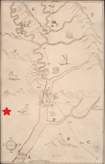
By the time settlers arrived, Native Americans had already left the area, though signs of their former occupation remained as noted in early land grant and deed descriptions. The meets and bounds of Francis Awbrey's 1728 patent along the Potomac at Point of Rocks used a landmark described as a great heap of stones called an Indian grave and Catesby Cocke's 1731 patent referenced a point on Kittoctin (now Catoctin) Mountain near the Indian fort.2

Little is recorded about the lives of the Indigenous People in the area, but one intriguing deed from 1741 suggests the location of a Potomac River crossing. The deed includes a sketch of a trail blaze on a Beech tree marked thus by the Indians.3 Many settlers would use this same crossing of the Potomac River near Loudoun Heights.
In 1707, Franz Louis Michel mapped the area, depicting an Indian long house in Maryland adjacent to a large island in the Potomac River. It was on the island that the Piscataway Indians established a fort in 1699 to enjoy the benefits of a supply of fresh fish. Christopher de Graffenried met them in 1712 on his exploration of the Shenandoah Valley and climbed Sugarloaf Mountain to draw his own map of the area.4 Pioneers, traders, and trappers likely had a presence in the area, but may have moved west before the first settlers arrived. Nevertheless, it seems that some of these early figures passed on Native American names for local streams to surveyors.
Quaker Settlement
The early Quaker settlers in the region were risk takers, though they were buffered from danger of Native American attacks by settlers in the Shenandoah Valley. They came with few possessions, willing to rely on natural resources and limited supplies for survival until their farms were established. The settlers had to clear land for farming, build houses and barns, plant orchards, and establish paths between settlements and shipping ports for conveying products to and from Great Britain.
William Dodd, who settled nearby in 1742, gave an account of his move from Pennsylvania. He didn't have a carriage to transport his family and belongings, so he purchased a small cart on credit and drove to Virginia. He described moving into a Strange Land where the Usual Articles for a Family's Support was hard to be gotten, and money not to be made immediately. He sold the cart after arriving in Virginia for 1,000 pounds of tobacco, but then had no way to transport a hogshead of tobacco to market. Dodd brought a small amount of money with him in the form of paper Pennsylvania pound and shilling notes. He also had Spanish coins, including double doubloons and pistoles.5
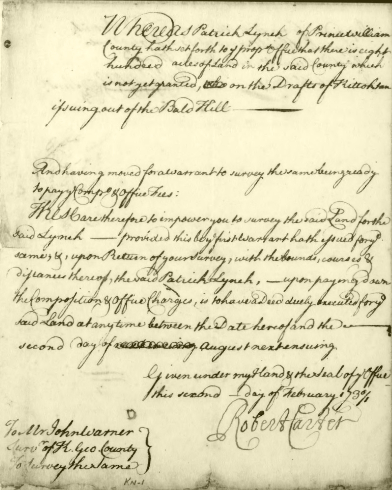
The land where Waterford is located was part of a larger tract of 703 acres that was identified by Patrick Lynch as ungranted land. He obtained a warrant that authorized the land to be surveyed. Prior to the survey, though, Lynch assigned the warrant to John Mead, a Quaker from Cecil County, Maryland, and his father-in-law, Richard Abrill.6 Catesby Cocke acquired the land in 1731 after Mead and Abrill failed to pay the composition, which was a title fee.7 That was the year Cocke became the first clerk of the Prince William County Circuit Court. (The area was part of Prince William County at the time.) Two years later, Cocke sold the tract to Mead.8
John Mead had a skill that would benefit him greatly as he carved a homestead out of the wilderness: he was a carpenter. His tools consisted of a complete set of turning tools for making wheels and round ware, a coarse handsaw, fine handsaw, broad axe, adze, augers, files, chisels, rasps, and a drawing knife. These tools were sufficient for building log houses. He farmed about eight acres of wheat, rye, and barley, and raised hogs, cattle, and horses. Mead owned a large spinning wheel for twisting wool into yarn and a smaller wheel for spinning flax into linen. His wife, Mary, likely manufactured their clothing from scratch by spinning, weaving, and sewing.9
It is possible, though not certain, that he and his wife Mary settled on his 703-acre tract since he was already a county resident when he purchased nearby land a couple months later.10

Amos Janney, a Quaker from Pennsylvania, may have leased, or had a contract to purchase, 253 acres of John Mead's 703-acre tract beginning about 1733 before obtaining a deed around 1737.11 It is speculated that Janney was living on the land ca. 1733 as evidenced by the paperwork needed for a Quaker to relocate. In order to be accepted into the Quaker Monthly Meeting associated with his new residence, Janney obtained a certificate in March 1733 from the Falls Monthly Meeting in Bucks County, Pennsylvania recommending Janney and his wife as Members in Unity. When Janney presented the certificate to the Nottingham Monthly meeting in June 1734, he was already living in Virginia.12
Mead continued to sell off the land. In 1742 he sold 147 acres to David Griffith.13 The remainder of the original tract, now down to 303 acres, was sold in 1743 to Francis Hague.14 Amos Janney and Francis Hague knew each other in Pennsylvania where they married sisters. It is on the land Francis Hague purchased that the village of Waterford would one day be founded.

At the time of Janney's move to Virginia, the area was mostly uninhabited and the land uncultivated. This soon changed. Janney was a land surveyor for Lord Fairfax's agent, which acquainted him with vacant land available for grants. John Mead occasionally assisted him with his surveys. All of the land in the region was surveyed, and most of these original survey plats still exist. Many surveys depict streams, including one called Amos's Branch named after Amos Janney, and occasionally a path would be indicated.15 One of the paths, in existence by 1742, extended from Amos Janney's land north to Thomas Johns's farm. Loyalty Road, as it extends out of Waterford, follows this path.16
Janney was instrumental in creating a Quaker community in the area by acquiring over 5,000 acres of land scattered about the region that he either sold or leased to other Quaker farmers.17 Much of the land remained forested, in part because Quaker farmers typically relied on their own labor to grow tobacco, a labor-intensive crop. Tobacco cultivation required frequent work by hand so field sizes were necessarily small.18 Some Quaker farmers obtained indentured servants to provide additional labor, including servants convicted of petty crimes in England and transported to the region by the tens of thousands.19
Religious Society
Religion in colonial Virginia was an integral part of society. The Anglican Church of England was the official church with governmental responsibilities at the local level, such as providing for the poor, sick, and orphans, for enforcing moral codes through the local court, and for collecting tithes. The first Anglican chapel in present-day Loudoun County was constructed from 1733-1735 near the Big Spring near the road that runs from Leesburg to Point of Rocks.20
Due to the growth in the area, the Anglican church established a new parish in 1748 and named it Cameron after Thomas, Lord Fairfax of Cameron. The district encompassed most of present-day Loudoun County and the western part of Fairfax County.21
In 1749, Rev. Charles Green, the rector, created a list of all the male heads of households in both the upper (Cameron) and lower (Truro) parishes. If a man was of a faith other than Anglican, Rev. Green specified his religion. According to Rev. Green's tithe list, there were 76 Quaker households in Cameron Parish. Quakers represented 11% of the taxable men in the parish, both free and enslaved. While not as prominent or numerous as the Quakers, other religions were represented in Cameron Parish, including 39 Catholic, 26 Presbyterian, 5 Anabaptist, and 5 other sectarian households.22 The Anglican church was tolerant of other religions for pragmatic reasons: they needed tenant farmers to support the local economy and to defend the Shenandoah Valley frontier from raids by Indigenous groups.
In 1744, eleven years after Janney settled here, local Quakers were given permission by the Society of Friends to establish a meeting of Quakers, which they called Fairfax Preparatory Meeting. (At this time, the area was part of Fairfax County.) Amos Janney held meetings in his house until the first meetinghouse was built.23 Although the Anglican Church of England was the official religion supported by public funds, the Quakers, who were accepted leaders in the community, formed their own religious and social society and lived according to their moral code.
Mercantilism During Colonial Rule
Virginia was a colony of Great Britain, and the crown retained ultimate ownership of all the land in the colony. The land between the Potomac and Rappahannock Rivers comprised the Northern Neck Proprietary, a land holding created in 1649 by King Charles II.24 Thomas, Lord Fairfax was sole owner of the rights to the Proprietary when this area was settled. He granted large tracts of land to those who paid him an annual rent. The wherewithal to pay the sum was often made by leasing land to tenant farmers who generated income by growing and selling crops. Lord Fairfax in turn paid a portion of the rent to the British Crown for their share of the profits.25 Farmers also paid a Tobacco Export tax based on the amount of tobacco exported from Virginia.26
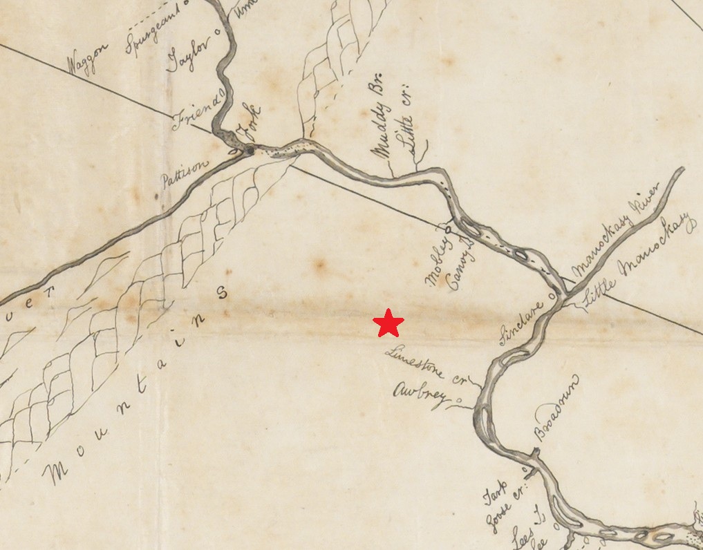
In order to resolve a boundary dispute, Lord Fairfax had the Northern Neck Proprietary surveyed. Early settlers were well established on Fairfax's land when Robert Brooke surveyed the Potomac River in a canoe, a mode of transportation adopted by Europeans that continued on the Potomac River throughout this period.27
Great Britain was an imperialistic empire that imposed a policy of mercantilism upon its colonies by limiting the trade of Virginia colonists through a series of Navigation Acts. The Virginia colonists were only permitted to trade with Great Britain, the British West Indies Islands, and Madeira. Furthermore, the colonists had to restrict their exports to raw materials and could only import products from Great Britain.
The colony was governed by Great Britain through a lieutenant governor and the Virginia General Assembly. Major William Gooch was lieutenant governor for most of the colonial period when this area was settled. He reported regularly to the Lords Commissioners of Trades and Plantations, an advisory board in Great Britain that sought to maximize profits generated by the colony for Britain while protecting the interests of British trade and manufacturing.
In 1735, Gooch wrote that there was only one potter's work for manufacturing pottery in the colony and four works for manufacturing iron, which was sent to Great Britain for the benefit of their trade. One forge and one air furnace operated in Virginia for making necessary tools.
To Great Britain they send Tobacco, Pitch, Tar, Skins, and Furrs; In return they have Necessaries. To the Islands, Beef, Pork, Tobacco, and Indian Corn. In return, Rum and Molasses. They purchase the Madeira Wines chiefly by Bills of Exchange.
Exerpt of Letter from Lieutenant Governor Major William Gooch to the Lords Commissioners of Trades and Plantations Regarding Virginia Colonists Trade Practices, 18 July 173528
Over time, Great Britain became lax in enforcement of the Navigation Acts as long as the colonies were profitable.
Agrarian Economy and the Development of Main Roads
At first, the area economy was driven by the harvest and sale of tobacco to colonial merchants. Because Virginia was a colony and Great Britain controlled the trade, all tobacco had to be shipped to Great Britain or the British-controlled West Indies. Since currency was scarce, tenant farmers were sometimes given the option to pay their rent by delivering a certain amount of tobacco or wheat to warehouses located at landings on the Potomac River. These warehouses had inspectors, required by Virginia law, who ensured that the colonists only shipped quality tobacco. Having consistent quality standards ensured that Virginia tobacco fetched a competitive price in England.
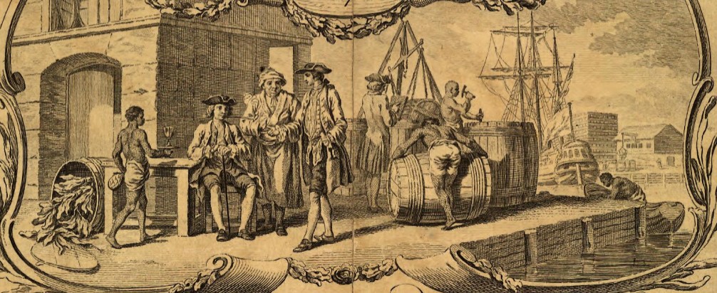
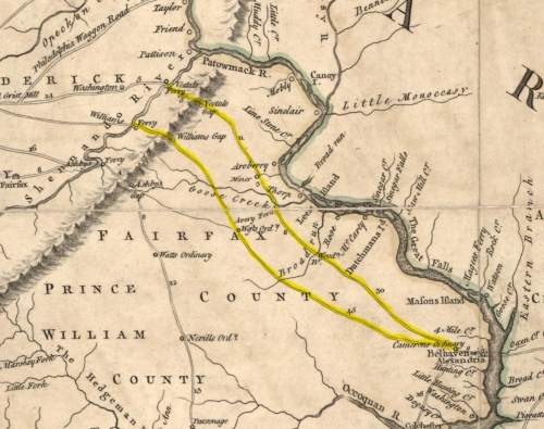
Most of the region's agricultural products were transported down one of two main roads that led from gaps in the Blue Ridge Mountains to landings on the Potomac River. Present-day Charles Town Pike follows a portion of the nearby main road from Vestal's Gap. A warehouse was established at the landing on the Potomac River, and it was here that colonial merchants loaded goods onto their ships. The town of Alexandria was established at this landing in 1749, three years after Amos Janney's death.29
During the settlement period, there were no villages in the "back country" where farmers lived distant from one another. Small villages, such as Colchester, formed at the tobacco landings on the Potomac River. Here, farmers received notes for the value of their tobacco that could be exchanged for goods received from England.
The control Britain exerted on trade was not limited to tobacco. England was very protective of its mainland farmers and restricted the import of wheat from the colonies to only those years when Great Britain had a poor harvest, which was rare in the 1730s and 1740s.30 Virginia eyed increasing trade with the British West Indies, but the climate there was not suitable for storage of wheat. However, it was possible to sell wheat that had already been ground into flour.
In 1745, the Virginia legislature, in an effort to develop greater trade in the West Indies, passed a law that established flour inspectors at the warehouses in an attempt to boost flour exports.31 Information that would suggest when Loudoun County farmers converted from tobacco to predominately wheat cultivation is scarce since the court order books written prior to 1749 are missing. However, it appears that flour milling in the area began to proliferate in the 1750s when prominent men of the area began to build grist mills. This shift in agricultural production from primarily tobacco to wheat cultivation marshaled in a new era for the region.
[Author's Note: The 1733 date associated with Waterford is the earliest known date of settlement in the immediate area. It is not the date that the village of Waterford was established, which wasn't for another 51 years, in 1784. Although Waterford was not a colonial village, it has an interesting history as a post-Revolutionary-war village.]
Footnotes
-
Loudoun County Northern Neck Land Grant Map, as viewed at https://loudoungis.maps.arcgis.com/apps/MapTools/index.html?appid=d3c4ba1031564f919ca28c9bb5a48350; Grants are available online at https://www.lva.virginia.gov/ ↩
-
Northern Neck Grant to Catesby Cocke, NN D:50, 597 acres, September 8, 1731, Northern Neck Grants and Patents, Library of Virginia. ↩
-
Deed from John Colvill to William Fairfax, PW DB E:199, January 3, 1740. ↩
-
Fairfax Harrison, Landmarks of Old Prince William Volumes I and II, Gateway Press, Inc., Baltimore, MD, 1987, pp. 97-100. ↩
-
Loudoun County Chancery Suit William Dodd v. Isaac Nicholas, index number 1768-002, as viewed at https://www.lva.virginia.gov/chancery/case_detail.asp?CFN=107-1768-002 ↩
-
Warner, John, Northern Neck Survey for Richard Averill and John Mead, Northern Neck Surveys, Reel 30, Library of Virginia, Richmond; Also, Fairfax County Deed Book A1(1)11 from John Mead to David Griffith, February 16, 1742 lists John Mead as a carpenter; Also, John Mead and Mary Abrell marriage, U.S., Quaker Meeting Records, 1681-1935, Chester County, Pennsylvania, New Market Monthly Meeting, Marriage Records 1704-1765, February 2, 1726, as viewed on ancestry.com, states that both John Mead and Mary Abrell were from Cecil County, Maryland. ↩
-
Grant to Catesby Cocke, Northern Neck Grant Book D, page 13. ↩
-
Prince William County Deed Book B, page 186. Mead was listed as a resident of Prince William County when he received the deed for the 703-acre tract. ↩
-
John Mead to Richard Poultney Deed for personal property, Fairfax County Deed Book A-197, May 17, 1744. Some of the property may have belonged to John's brother Samuel who also lived in the area. ↩
-
Deed from Thomas Thoms to John Mead and Henry Ballinger, Prince William County Deed Book (PW DB) D:116, January, 28 1733/4. ↩
-
In order to be accepted into the Quaker Monthly Meeting associated with his new residence, Janney obtained a certificate in March 1733 from the Falls Monthly Meeting in Bucks County, Pennsylvania recommending Janney and his wife as Members in Unity. When Janney presented the certificate to the Nottingham Monthly meeting in June 1734, he was already living in Virginia. Prince William County Deed Book C:400 per index, book is missing. ↩
-
Swarthmore College; Swarthmore, Pennsylvania; Minutes, Chester County, Nottingham Monthly Meeting, 1730-1756; as viewed on Ancestry.com U.S., Quaker Meeting Records, 1681-1935. ↩
-
Fairfax County Deed Book A1:11, February 16, 1742. David Griffith acquired 147 acres from John Mead, carpenter, for 12 pounds Sterling [.0816 pounds/acre], part of the 703-acre tract. ↩
-
Fairfax County Deed Book A1:282, March 19, 1743. Francis Hague acquired 303 acres from John Mead for 30 pounds. The boundary cut around the creek. [.099 pounds/acre]. ↩
-
Northern Neck grant survey, NN E:441, Cocke and Mercer survey, 5,985 ac, 13 Apr 1742, Courtesy Library of Virginia. ↩
-
Catesby Cocke grant survey, Northern Neck Grant E:441, April 13, 1742. Survey, Northern Neck Grants E, 1736-1742, p. 439-440 (Reel 291), Library of Virginia. ↩
-
Loudoun County Northern Neck Land Grant Map, as viewed at https://loudoungis.maps.arcgis.com/apps/MapTools/index.html?appid=d3c4ba1031564f919ca28c9bb5a48350; Grants are available online at https://www.lva.virginia.gov/; See also Fairfax County Deed Books. ↩
-
Gutheim, Frederick, The Potomac, Grosset & Dunlap, New York, 1968, p. 55. ↩
-
Coldham, P. Wilson. (1993). The complete book of emigrants, 1751-1776: a comprehensive listing compiled from English public records of those who took ship to the Americas for political, religious, and economic reasons; of those who were deported for vagrancy, roguery, or non-conformity; and of those who were sold to labour in the new colonies. Baltimore, Md.: Genealogical Publishing. Also, Lilly, Thomas. Irish Convicts, Virginia Gazette, 11 Feb 1773, p. 4. Also, Hague, Francis. Virginia Gazette, 09 Nov 1769, p. 4., col. 2, as viewed at https://research.colonialwilliamsburg.org/DigitalLibrary/va-gazettes/ ↩
-
Fairfax Harrison, Landmarks of Old Prince William: A Study of Origins in Northern Virginia (Richmond: Priv. print., The Old Dominion Press, 1924), 287. ↩
-
Fairfax Harrison, Landmarks of Old Prince William: A Study of Origins in Northern Virginia (Richmond: Priv. print., The Old Dominion Press, 1924), 289, citing Henings Statutes, vi, 234. ↩
-
Green, Charles Rev., Fairfax County List of Tithables, Charles Green Papers, Manuscript Division, Library of Congress, 1749, obtained from Library of Congress by Linda Stokesbury Brennon 17 Jul 2018, viewed at https://usgenwebsites.org/VAFairfax/resources/1749fairfaxtithables.pdf ↩
-
Hough, John, The Memorial of Fairfax Monthly Meeting Concerning our Esteemed Friends & Elders, Amos & Mary Janney, July 25, 1767, U. S. Quaker Meeting Records, 1681-1935, Philadelphia Yearly Meeting, Minutes 1766-1773, as viewed on Ancestry.com. The location and description of the first meetinghouse is unknown. ↩
-
Charter of 1669 affirms original charter of 18 Sep 1649, Virginia Lords Commissioners of Trades and Plantations, British Archives, London. ↩
-
The Account of his Majesty's Revenue of Quitrents from the 25th of April 1734 to the 25th of April 1735 Arising within this Colony of Virginia, Virginia Lords Commissioners of Trades and Plantations (Board of Trade) Letterbook, British Archives, London. ↩
-
Statement of the Revenue Arising in Virginia from the Tobacco Export Tax, Colonial Records Project No. 00709, Library of Virginia. ↩
-
William Dodd vs. Isaac Nicholas, Loudoun County chancery case 1768-002 (M7015), as viewed at https://old.lva.virginia.gov/chancery/full_case_detail.asp?CFN=107-1768-002#img ↩
-
Letter from Lieutenant Governor William Gooch to the Lords Commissioners of Trades and Plantations, 18 Jul 1735, Virginia Lords Commissioners of Trades and Plantations (Board of Trade) Letterbook, British Archives, London. ↩
-
Preisser, Thomas M., "Eighteenth-century Alexandria, Virginia, before the Revolution, 1749-1776" (1977). Dissertations, Theses, and Masters Projects. Paper 1539623705. https://dx.doi.org/doi:10.21220/s2-9jf6-s176 ↩
-
Sharp, Paul, The Long American Grain Invasion of Britain: Market integration and the wheat trade between North America and Britain from the Eighteenth Century, Department of Economics, University of Copenhagen, Copenhagen, Denmark. ↩
-
Laws of Virginia, An Act, for continuing and amending an Act, intituled, an Act, for inspecting, weighing, and stamping all pork and beef, packed in this colony, or imported for sale, before the same shall be sold here, or shipped for exportation: And to amend the Act, intituled, an Act, for ascertaining the gauge of barrels for pork, beef, tar, and pitch; and for inspecting, weighing, and stamping all flour exported, Chapter VIII, February 19, 1745. ↩